Integrated Municipal Information System (IMIS)
The Integrated Municipal Information System (IMIS) is a comprehensive digital platform designed to transform how municipalities manage sanitation systems and services, aligning with the principles of Citywide Inclusive Sanitation (CWIS) to achieve Sustainable Development Goal (SDG) 6.2. IMIS equips municipal authorities with tools to plan, monitor, and optimize sanitation service delivery, ensuring equitable access for all, particularly underserved communities. By integrating geospatial data, real-time service tracking, and sanitation-specific analytics, IMIS supports evidence-based decision-making and enhances resource allocation to improve sanitation outcomes.
IMIS also functions as a Digital Public Infrastructure (DPI) at the sub-national level, facilitating the generation and organization of critical data for urban sanitation management. Beyond supporting local governance, IMIS serves as a foundational data system that feeds data into national-level systems for monitoring CWIS indicators and other metrics critical for achieving sanitation targets. This capability ensures alignment between municipal operations and broader national objectives, creating a seamless flow of actionable data across governance levels.
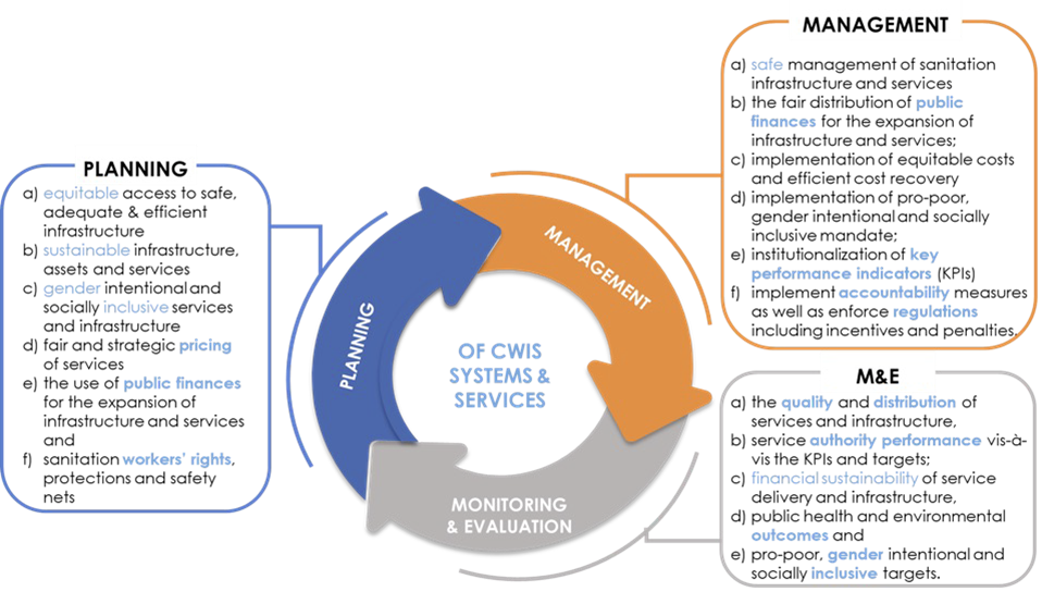
IMIS supports the Planning, Management, and Monitoring & Evaluation (M&E) framework for CWIS systems and services (see Figure 1). This framework emphasizes a structured approach to achieving inclusive and sustainable sanitation outcomes. The Planning component focuses on equitable and gender-inclusive strategies, sustainable financing, and transparent pricing mechanisms. The Management component ensures the safe, accountable, and financially sustainable operation of sanitation systems. The M&E component assesses service quality, equitable distribution, and the performance of sanitation authorities. Together, these components create a continuous feedback loop that helps municipalities refine their strategies and align them with national sanitation goals.
|
|
|
Fig. 1 Planning, Management and Monitoring & Evaluation Framework for implementing CWIS Approach |

IMIS comprises ten functional modules, seven of which are core modules directly addressing sanitation systems and services, such as faecal sludge management, sewer connections, and public toilet operations. The remaining three value-added modules enhance complementary municipal services, including property tax collection, solid waste management, and water supply billing. Combined with the Urban Management Decision Support System (UMDSS)—a powerful tool for spatial analysis, mapping, and decision-making—IMIS empowers municipalities to adopt CWIS principles while contributing to broader urban governance. Each of these modules are discussed under sub chapter “Modules”.
Built on robust open-source technologies like PHP, PostgreSQL, and OpenLayers, IMIS is made freely available under the Creative Commons Attribution-NonCommercial-ShareAlike 4.0 International (CC BY-NC-SA 4.0) license. This licensing ensures that municipalities and stakeholders can access, use, and adapt the system to their needs while promoting collaboration and innovation in sanitation and urban governance. Its intuitive dashboards enable municipalities to track CWIS indicators, Key Performance Indicators (KPIs), and other metrics essential for sanitation management. As a sub-national data system and DPI, IMIS strengthens municipalities’ ability to achieve sanitation objectives locally while feeding reliable, standardized data into national systems for effective CWIS monitoring and governance.
The Integrated Municipal Information System (IMIS) consists of ten functional modules: seven core modules and three value-added modules (see Figure 2). The seven core modules include the Building Information Management System (BIMS), Utility Information Management System (UIMS), Faecal Sludge Information Management System (FSIMS), Community Toilet / Public Toilet Information Management System (CTPIMS), Sewer Connection Information Management System (SCIMS), Public Health Information Support System (PHISS), and the Urban Management Decision Support System (UMDSS). The three value-added modules are the Property Tax Collection Information Support System (PTCISS), Solid Waste Information Support System (SWISS), and the Water Supply Information Support System (WSISS). These value-added modules primarily support property tax collection, solid waste management, and water supply billing units, utilizing IMIS as a digital infrastructure to enhance services and improve revenue collection processes. Unlike the core modules, these value-added modules rely on data imported from respective municipal units during their regular business processes, as IMIS does not create data for them. Additionally, they do not directly impact sanitation systems and services under the Citywide Inclusive Sanitation (CWIS) approach.
Conversely, all core modules, except for UMDSS, generate and utilize their own data for various analyses, significantly contributing to the management of sanitation systems and services within the CWIS framework. UMDSS, while not creating data itself, consolidates data from other modules to facilitate decision-making related to sanitation systems, services, and broader urban management issues through its various analytical tools. Access to these modules is determined by the functional roles of municipal staff, executives, and stakeholders, ensuring their integration into daily municipal operations for effective management.
The use of these modules must be embedded into the regular workflows of corresponding departments or units within the municipality. For instance, the FSTP operator, responsible for recording logs of faecal sludge disposed of at the FSTP, is required to use the “Sludge Collection” functional sub-module within FSIMS. Similarly, emptying operators must use the IMIS-provided mobile application to capture data during containment emptying processes under the relevant sub-modules. This integration ensures that information within IMIS is continuously updated without the need for additional resources dedicated solely to data entry.
Each of these ten functional modules is discussed in detail in subsequent sections of this chapter. Additionally, IMIS includes a dedicated Settings module, which focuses on system administration and is covered at the end of the chapter. This structured approach ensures that IMIS is seamlessly integrated into the municipality’s operational framework, supporting both sanitation and urban management.

Figure 1 Functional Modules of IMIS
1. Building Information Management System (BIMS)
The BIMS is a core module of the IMIS that serves as a comprehensive database of all buildings within a municipality. It encompasses detailed information about each building, including: Physical attributes (structure type, number of floors, and year of construction); Location details (address and geographical coordinates with building footprints; Usage and ownership (Building usage, ownership status, and associated tax codes); Utilities and services (sources of water, solid waste management services, access to sanitation, access to roads, etc); Demographics and classifications (basic demographic data and classifications for low-income community areas). Buildings are central to IMIS, functioning as the foundational entities that interconnect all other components essential for efficient municipal service delivery.
The building database in IMIS is established using a GIS framework. High-resolution satellite or drone imagery is used to digitize building footprints, which are then verified through field checks and house-to-house surveys. House-to-house survey also collects all other required attributes data about buildings.
New buildings constructed post-IMIS implementation are recorded through the IMIS mobile application during the building permit process and updated for new constructions. The app, currently available for Android, captures building footprints and related data for new structures. Additional building attributes are updated during municipality’s business process in delivering various services such as sanitation assessments, sanitation service delivery and other services. However, this need to be incorporated in municipality’s service delivery policy.
BIMS provides interactive dashboard dedicated for building related information. This dashboard provides visual insights into building data from multiple perspectives. BIMS provides comprehensive interfaces and tools for data entry, updates, queries, and analysis. The system has map-based integration feature that provides geospatial visualization tools for location identification. The module has data extraction tools that has capability for generating data in various formats, including CSV, Shapefiles, and KML files.
BIMS offers municipalities valuable insights into Building infrastructure status, utility and service access and the critical data for planning, management and monitoring and evaluation of sanitation system and services in CWIS approach.
The data maintained by BIMS helps municipality to monitor the CWIS indicators such as (i) % of LIC population with access to safe individual toilets / % of total population with access to safe individual toilets, (ii) Population with access to safe individual toilets, and (iii) Low income community (LIC) population with access to safe individual toilets.
2. Utility Information Management System (UIMS)
UIMS, a core module of the IMIS, is designed to manage detailed spatial and attribute data for municipal utilities such as roads, stormwater drains, water supply networks, and sewer systems. UIMS plays a critical role in achieving CWIS by enabling municipalities to monitor sanitation infrastructure, identify service gaps, and ensure equitable access to sanitation services, particularly for low-income community (LIC) areas. Through its integration with the BIMS, UIMS provides granular insights into utility connectivity for each building, including sewer and drainage links, and water supply access. This integration helps municipalities target underserved areas, plan infrastructure expansions, and prioritize investments in sanitation services.
A key feature of UIMS is its interactive dashboard, which delivers real-time visualizations on sanitation-related utilities. The system empowers municipalities to monitor sanitation coverage trends, identify gaps, and make data-driven decisions to address inequities in service delivery. UIMS also includes advanced map-based input tools integrated with the UMDSS, allowing municipalities to add or update utility infrastructure directly within the platform. Currently this tool is available for creating and updating road only. In case of other utilities, they need to be digitized and merged with existing data and import in corresponding utilities database of IMIS with the help of skilled GIS people. In case of attribute data, they can be updated for all kind of utilities directly from the user interface. UMDSS has provided tools to export data in flexible formats, such as CSV, SHP, and KML ensuring seamless sharing and integration with other municipal services.
3. Faecal Sludge Information Management System (FSIMS)
The FSIMS is another core and most important module CWIS. This module enables municipality to digitalize and manage all data related to sanitation systems and services. FSIMS digitalize the complete sanitation service chain from application request for emptying service to the safe disposal of faecal sludge at the treatment plant and the reuse of the treated waste.
The FSIMS is further categorized into five sub-modules:
a. FSM Dashboard (FSMD): The FSMD provides information related FSM services, overall, from containment emptying to transfer and disposal of waste in the FSTP. FSMD provides information about the number of containments; service providers; resources used for service delivery; applications received and responded; containments emptying status, volume of sludge collected, emptied and disposed; and the revenue generated,
b. Containment Information Management System (CIMS): The CIMS maintains the information about the containments in the city, with their location information and attribute information such as building identification number (in case of multiple building served one containment, BIN of main building responsible for taking care of the containment), sanitation system type, dimensions, volume, last emptying date, next emptying date, etc. If a building is connected to a sewer network, that information is maintained in the building database. However, this module does not include a separate feature for adding new containments, if new containment must be added, it has to be updated in corresponding building in building database, through BIMS. A containment may be shared by multiple buildings or vice versa.
c. Service Provider Information Management System (SPIMS): The SPIMS maintains the information related to the sanitation service providers registered with the city that provide emptying services within the city. This information is maintained by municipal authority whereas, two other functionalities employee information and desludging vehicles for service provider to maintain their information about their employees and the desludging vehicles. Only those service providers, employee and vehicles registered in this system are eligible to provide emptying, transporting and disposing faecal sludge in the FSTP or area designated by the municipality. These information help municipality and service provider for efficient management of the resources and efficient service delivery. The information provided by SPIMS also helps monitoring KPIs set by municipality for service provider and tracking emptying vehicle to ensure that the waste emptied from the containment is transported and disposed in the area designated for disposing waste or FSTP allocated by the municipality.
d. Treatment Plant Information Management System (TPIMS): The TPIMS maintains the information related to the treatment plants that could be FSTP, Centralized Wastewater Treatment Plant, Decentralized Waste Water Treatment Plant or Co-treatment Plant, those used by the city to dispose and treat collected faecal sludge or waste water. In addition to this, this sub-module also maintains water sample test data with the standard parameters used for monitoring the performance of the treatment plants in the city.
The information maintained by TPIMS along the information maintained by BIMS and the ESIMS, helps municipal to monitor the CWIS indicators such as (i) FS treatment capacity as a % of total FS generated from non-sewered connections, (ii) FS treatment capacity as a % of volume disposed at the treatment plant, (iii) WW treatment capacity as a % of total WW generated from sewered connections and greywater and supernatant generated from non-sewered connections, and (iv) Effectiveness of FS treatment in meeting prescribed standards for effluent discharge.
e. Emptying Service Information Management System (ESIMS): The Emptying Service IMS digitalizes the sanitation service chain and enables the city to manage the entire sanitation service chain, starting from application requests for emptying service from the customer to the safe disposal of faecal sludge at the treatment plant. All the activities involved in this process can be monitored in real-time through ESIMS. The module is divided into four categories according to the different stages of the sanitation service chain i.e. application, emptying, sludge collection and feedback. The complete service chain is managed and maintained through the application section; however, the individual sections maintain further detailed information. There are several functional modules under this sub-module:
§ Application – this functional module is accessible to helpdesk and FSTP operator. The helpdesk use it for receiving and maintaining application for customer’s emptying request and collecting and maintain feedback data. FSTP operator use it for updating sludge transferred from the emptied containment and disposed in the FSTP. There is a function to generate report of emptying service under this functional module. Helpdesks generally are the part of the municipality’s sanitation department, emptier are part of the service providers and FSTP operators can be part of the municipality or the private operator as of municipality’s policy.
§ Emptying – there is an easy-to-use native mobile application (android) that allows collection of the emptying information while providing the emptying service, such information can be updated in real-time. The mobile application is used by emptier to collect the information such as emptying start and end time, number of trips, total cost for emptying, and the payment receipt number. Emptying details can be viewed in real-time by help desk and other municipal staff who has access to this module.
§ Sludge collection – FSTP operator in FSTP updates the FS disposal record that includes date, time and volume of waste disposed in the FSTP through the functional module Application through the web app as the waste is transferred and disposed in FSTP. Help desk can view these records in real-time through this functional module.
§ Feedback – this functional module is accessible to the helpdesk, after completing sanitation service chain from emptying to disposal of the waste in the FSTP.
§ Help desks – this functional module is used to create help desk and update their information. Help desk generally are under municipality itself, but the system has capability of managing multiple help desks.
Data maintained by FSIMS along with the building data and LIC data enables CWIS Information Management System to generate CWIS indicators such as (i) IHHL onsite sanitation system that have been desludged, (ii) Collected FS disposed at the treatment plant or designated disposal site, (iii) Low income onsite sanitation systems that have been desludged, (iv) FS collected from LIC that is disposed at treatment plant or designated area, (v) Educational institutions where FS generated is safely transported to TP or safely disposed in situ, (vi) Healthcare facilities where FS generated is safely transported to TP or safely disposed in situ, and (vii) Desludging services completed mechanically or semi-mechanically.
The data export tools under FSIMS allows users to export data in CSV, Shape and KML format where applicable.
4. Community Toilet / Public Toilet Information Management System (PTCTIMS)
The PTCTIMIS is another core module of the system that maintains the information about the Public Toilets (PT) and Community Toilets (CT) in the city. The module enables municipal authority to maintain geographic locations of the PTs and the CTs in the city with their capacities and facilities along with daily user logs in case of PTs. In case of CTs, PTCTIMS maintains the number of households and the population served by CTs, based on the household and population data maintained by building database in the system. Data export feature of the module eanbles users to export data PT/CT data in CSV format. Mapping features of UMDSS with this data enables municipal authorities to map the locations of the PTs/CTs with their operational condition and it has also provided a tool to map the buildings which are served by a specific CT.
CT information along with building information maintained by PTCTIMS helps monitoring four major CWIS indicators (i) Dependent population with access to safe shared facilities, (ii) Shared facilities that adhere to principles of universal design, (iii) Shared facility users who are women, and (iv) Average distance from household to shared facility. Similarly, PT information along with containment emptying data enables municipal authority to monitor CWIS indicators (i) PT where faecal sludge generated is safely transported to treatment plant or safely disposed in situ, (ii) PT that adhere to principles of universal design, and (iii) PT users who are women.
5. Sewer Connection Information Support System (SCISS)
The SCISS is a core module that enables the city to maintain information on new sewer connections established between a building and sewer network within the city. This module provides a native mobile application (android) that allows the collection of the unique ID of both the building and the corresponding sewer network through a field survey. The collected building ID as well as sewer ID are maintained by this module, and once approved it is reflected in the BIMS, which updates the sanitation system and utility information of the building.
6. Public Health Information Support System (PHISS)
PHISS is another core module of the IMIS, designed to empower municipalities in monitoring and addressing public health and sanitation challenges. PHISS enables the collection and maintenance of water sample data from various sources, including groundwater, surface water, and treated wastewater, to ensure compliance with water contamination standards. This functionality directly aligns with the CWIS objective of monitoring environmental outcomes associated with sanitation systems. Additionally, PHISS records and tracks cases of waterborne diseases across the city, providing municipalities with crucial data to understand and mitigate public health risks.
One of the standout features of PHISS is its ability to maintain spatial and attribute data related to hotspot areas where waterborne diseases, such as diarrhea, cholera, dysentery, and typhoid, have been detected. The system also tracks fatalities linked to these diseases, offering a comprehensive overview of the impact on affected households and populations. By integrating this information with the UDSS municipal authorities can conduct detailed analyses of disease prevalence and its underlying causes. This data-driven approach enables strategic planning, targeted interventions, and efficient allocation of resources to reduce health risks in vulnerable areas.
Water sample data and waterborne cases data maintained by PHISS helps municipality to monitor the CWIS indicators (i) Water contamination compliance of the water sources such as groundwater, surface water and treated wastewater, and (ii) Incidence of faecal-oral pathway diseases (e.g. diarrhea, cholera, dysentery and typhoid). With this information, municipalities can assess the effectiveness of sanitation systems in protecting public health and identify areas requiring urgent attention. By addressing these indicators, PHISS supports municipalities in achieving CWIS objectives, ensuring safe water quality and reducing the prevalence of sanitation-related diseases. The data export tools under PHISS allows users to export data in CSV, Shape and KML format where applicable.
7. Urban Management Decision Support System (UMDSS)
The UMDSS is one of the core and powerful tool in IMIS, it provides advanced capabilities for spatial analysis, mapping, data export, and dashboard visualizations. These tools empower city authorities to engage in evidence-based planning, management, monitoring, and decision-making for planning, management and monitoring and evaluation of sanitation system and services as well as a broader municipal urban management activities. In addition to the UMDSS module, there are IMIS Dashboard, Building Dashboard under BIMS, FSM Dashboard under FSIMS, Utility Dashboard of IMIS, CWISIMS Module including CWIS and KPI dashboard under CWISIMS are also has been considered as the components of UMDSS.
7.1 UMDSS
The UMDSS provides Export Data and Map Feature Sub-modules.
Export Data:
§ The Export Data sub-module enables users to export data layers in flexible formats such as SHP and KML. Users can customize exports by selecting specific ward(s) or combining layers to suit their needs.
Map Feature:
§ The Map Feature is a powerful interactive map interface which provides a dynamic platform to visualize and analyze spatial data created by various modules and sub-modules in IMIS. It displays all spatial information with categorical styling based on attribute inforation, presenting summarized layers at city, ward and 0.5 km grid levels.
§ The interface includes various spatial and complex tools provide both basic and advanced functionalities, catering to a wide range of municipal operations. From navigation and visualization to sanitation-specific analyses and data updates, these features enhance decision-making by offering precise and actionable insights. These tools are – (i) Navigation and Map Interaction Tools (Zoom In & Zoom Out, Municipal Extent, Navigate, Info, Coordinate Information, Locate Point by Coordinate, Measurement Tools, Measure Distance, Measure Area, (ii) Measurement Tools (Measure Distance, Measure Area), (iii) Printing and Support Tools (Print Map, Help), (iii) Sanitation-Specific Analysis Tools (Find Nearest Road, Find Building Connected to Containment, Find Containment Connected to Building, Find Associated Building, (iv) Editing Tools (Add Roads, Remove Markers)
The integration of tools like Find Nearest Road and Containment Analysis directly supports Citywide Inclusive Sanitation (CWIS) goals, while features like Measure Area, Print Map, and Add Roads contribute to broader urban management and planning efforts. By using these tools, municipal authorities can efficiently monitor sanitation systems, plan infrastructure upgrades, and ensure equitable service delivery across the city.
§ UMDSS also offer some specialized tools – (i) Service Delivery Tools for tracking (Applications, Emptied Applications Not Reached to Treatment Plant, Containments Proposed to Be Emptied, Feedback Chart (FSM Service Quality), (ii) General Tools for tracking (Buildings by Structure Type, Property Tax Collection, Water Supply), (iii) Data Export Tools (Filter by Wards, Export Data Set, Building Owner Information), (iv) Decision Tools (Tax Due Buildings, Sewers Potential Buildings, Buildings to Sewer, Buildings to Road, Hard to Reach Buildings, Building Close to Water Bodies, Buildings Using Community Toilets, Area Population), (V) Summary Information Tools (Summary Information Buffer Filter, Water Bodies Buffer Summary Information, Wards Summary Information, Road Buffer Summary Information, Point Buffer Summary Information).
These tools enhance decision-making by providing targeted insights into property, utility, and demographic data. They allow municipalities to analyze specific areas, prioritize interventions, and support efficient planning, management and monitoring and evaluation of CWIS sanitation system and services, and overall urban management.
7.2 CWIS Information Management System (CWISIMS):
CWISIMS is a vital module of the IMIS that provides tools to generate CWIS indicators for the city and Key Performance Indicators (KPIs) to monitor the performance of sanitation service providers for a specified year. CWISIMS allows municipalities to set targets for each indicator in alignment with city policies and standards, and it includes a dashboard for the visualization of these indicators. The generated indicator data is maintained in a database, enabling easy access and review when needed, ensuring effective monitoring and planning.
(i) CWIS Dashboard - The CWIS Dashboard tracks 22 sanitation indicators (Annex 1), which are generated annually. These indicators are informed by data maintained across various modules and sub-modules within IMIS, making them integral to understanding citywide sanitation performance. The indicators are based on the CWIS framework developed by Athena Informatics, ensuring consistency with globally recognized standards for inclusive sanitation monitoring. This dashboard provides municipalities with a centralized platform for tracking sanitation progress and assessing the effectiveness of implemented policies and services.
(ii) KPI Dashboard – The KPI Dashboard complements the CWIS Dashboard by focusing on the performance of sanitation service providers. It monitors seven critical KPIs (1.Application Resposne Efficiency, 2. Customer Satisfaction, 3. PPE Compliance, 4. Safe Desludging, 5. Faecal Sludge Collection Ration, 6. Resonse Time, 7. Inclusion), which are also generated annually, using sanitation service data related to faecal sludge management (FSM) service delivery. These KPIs are designed to evaluate the efficiency and quality of services provided by sanitation operators, based on metrics developed by SNV Bangladesh. By leveraging this dashboard, municipalities can benchmark service provider performance and identify areas for operational improvement within their sanitation systems.
CWISIMS, through its dual focus on CWIS indicators and KPIs, provides municipalities with robust tools for monitoring and improving their sanitation systems. By aligning indicator and KPI tracking with international standards and municipal goals, it ensures data-driven decision-making and continuous improvement in sanitation service delivery and management.
7.3 Dashboards
There are all together six Dashboards considerd as the components of UDSS of the IMIS includes six dashboards that serve as its core components: (i) IMIS Dashboard, (ii) Building Dashboard, (iii) FSM Dashboard, (iv) Utility Dashboard, (v) CWIS Dashboard, and (vi) KPI Dashboard. Five of these dashboards have been discussed under their respective functional modules and sub-modules. The remaining dashboard, the IMIS Dashboard, is detailed below.
The IMIS Dashboard serves as the central platform within the IMIS, offering a comprehensive overview of municipal data. It integrates information on building infrastructure, utilities (such as roads, drains, sewer, and water supply), sanitation systems and services, public and community toilets, public health, tax collection, water bill payments, and solid waste management. This dashboard provides municipalities with a unified interface for monitoring and managing citywide operations effectively, supporting informed decision-making and efficient service delivery.
The Urban Management Decision Support System (UMDSS) enables municipalities to implement Citywide Inclusive Sanitation (CWIS) principles, supporting the planning, monitoring, and management of sanitation systems and services through a CWIS-focused approach. It also enhances revenue collection processes, including tax collection, water bill payments, and fees for solid waste management services, while providing actionable spatial insights to improve overall urban management. With its powerful analytical tools, UMDSS empowers municipalities to achieve greater efficiency, transparency, and inclusivity, not only in sanitation management but also in broader urban governance and service delivery.
8. Property Tax Collection Information Support System (PTCISS)
PTCISS is a value-added module integrated into the Integrated Municipal Information System (IMIS), designed to help municipalities monitor and manage property tax collection citywide through powerful map-based visualization tools. It enables city authorities to import property tax data maintained by the municipal property tax collection department into IMIS using a user-friendly data import tool supporting CSV formats. Once the data is integrated, property tax collection information is displayed in graphical formats on the IMIS dashboard and visualized on maps using tools provided by UMDSS. This facilitates quick and intuitive analysis of tax collection status across various parts of the city.
Mapping property tax data provides actionable insights by identifying high-default areas (regions with a significant number of defaulters) and efficient collection zones (areas with fewer defaulters or higher compliance rates). These insights enable the property tax department to focus on areas requiring attention, thereby improving efficiency and compliance. The information generated by PTCISS empowers city authorities to engage in strategic planning and evidence-based decision-making, allowing them to: (a) develop better tax collection strategies, (b) formulate effective policies to increase compliance, and (c) plan for equitable tax management across different city regions.
PTCISS also includes Data Export Tools, enabling municipal authorities to export building data along with their tax payment status. Additionally, it highlights mismatched tax records between the building data maintained in IMIS and the input tax data provided by the property tax department. This functionality helps identify and resolve discrepancies, ensuring data accuracy and transparency.
Currently, PTCISS relies on periodic manual updates using CSV-based imports to maintain data accuracy. However, the system is designed to be future-ready, with the capability to support real-time data integration through an API if the city’s property tax collection system provides connectivity access. This upgrade would enable automated and efficient data synchronization as municipal technology evolves.
By leveraging the features and insights provided by PTCISS, municipalities can streamline property tax management, improve transparency, and enhance revenue collection efficiency. These improvements contribute significantly to better urban governance and equitable service delivery.
9. Solid Waste Information Support System (SWISS)
The SWISS that enhances the management of solid waste services and fee collection. The module includes a tool for importing a municipality’s solid waste customer data, including their last solid waste management service fee payment date, in CSV format. Based on this imported data, the SWISS module generates and maintains solid waste management customer records in IMIS, along with their fee payment status. It also provides tools to export building data with their solid waste service fee payment status and identifies discrepancies by highlighting records that exist in the municipality’s solid waste customer database but are missing from IMIS.
Using the imported data, UMDSS in IMIS helps municipal authorities map buildings with or without solid waste management services and their respective fee payment statuses. This mapping capability enables municipalities to monitor service coverage, assess the status of fee collections, and identify geographic trends in solid waste management service delivery. By integrating solid waste management customer data with building records in IMIS, the SWISS module equips municipal authorities with actionable insights to make informed decisions regarding solid waste services.
The visualized data provided by SWISS supports municipalities in formulating policies to enhance the solid waste management service and fee collection processes. It also aids in optimizing resource allocation and improving overall service delivery by identifying areas requiring attention or adjustments. This integration is currently carried out manually on a periodic basis to ensure the data in IMIS remains up-to-date. Like the PTCISS module, SWISS does not yet support real-time data integration through an API.
10. Water Supply Information Support System (WSISS)
The WSISS is another value-added module within the IMIS, designed to enhance the management of water supply services and fee collection. The WSISS includes a data importing tool that allows municipalities to upload water supply customer data, including their last fee payment date, in CSV format. Based on this imported data, the WSISS module generates and maintains records of water supply customers along with their fee payment status. It also provides tools to export building data with their water supply service and fee payment statuses and highlights discrepancies by identifying records present in the municipality’s water supply customer database but missing in IMIS.
Using the imported data, the UMDSS in IMIS enables municipal authorities to visualize the water supply fee payment status of buildings in maps of the City within IMIS. This capability allows municipalities to monitor fee collection statuses and assess geographic trends in water supply fee payments. By integrating water supply customer data with building information in IMIS, the WSISS module equips municipal authorities with actionable insights to make informed decisions regarding water supply services.
The visualized data provided by WSISS supports the development of policies aimed at improving water supply fee collection processes, optimizing resource allocation, and enhancing overall service delivery. This integration helps municipalities target areas requiring attention, ensuring more effective and equitable water supply service management.
Currently, as with the PTCISS and SWISS modules, the integration of data into WSISS must be carried out manually on a periodic basis to maintain accuracy.
11. Settings
This is a module to allows administrators to manage user access and control permissions within the system. Features includes :
User Credentials - securely store and manage user authentication details, including usernames, passwords options.
Roles Management- Create and assign roles to users, defining their access level and responsibilities. Roles can be customized to reflect specific job functions.
Permissions Control - fine-tune access by assigning permissions to roles or individuals, ensuring users can only interact with data and features relevant to their role.
Annex 1
CWIS Indicators Used in IMIS (Ref. Athena Informatics)
|
SN |
Indicator |
Code |
|
1 |
% of LIC population with access to safe individual toilets / % of total population with access to safe individual toilets |
|
|
2 |
% of Population with access to safe individual toilets |
SF-1a |
|
3 |
IHHL OSSs that have been desludged |
SF-1b |
|
4 |
Collected FS disposed at treatment plant or designated disposal site |
SF-1c |
|
5 |
FS treatment capacity as a % of total FS generated from non-sewered connections |
SF-1d |
|
6 |
FS treatment capacity as a % of volume disposed at the treatment plant |
SF-1e |
|
7 |
WW treatment capacity as a % of total WW generated from sewered connections and greywater and supernatant generated from non-sewered connections |
SF-1f |
|
8 |
Effectiveness of FS treatment in meeting prescribed standards for effluent discharge and biosolids disposal |
SF-1g |
|
9 |
Low-income community (LIC) population with access to safe individual toilets |
SF-2a |
|
10 |
LIC OSSs that have been desludged |
SF-2b |
|
11 |
FS collected from LIC that is disposed at treatment plant or designated disposal site |
SF-2c |
|
12 |
Dependent population (without IHHL) with access to safe shared facilities |
SF-3a |
|
13 |
Shared facilities that adhere to principles of universal design |
SF-3b |
|
14 |
Shared facility users who are women |
SF-3c |
|
15 |
Average distance from HH to shared facility (m) |
SF-3e |
|
16 |
PT where FS generated is safely transported to TP or safely disposed in situ |
SF-4a |
|
17 |
PT that adheres to principles of universal design |
SF-4b |
|
18 |
PT users who are women |
SF-4d |
|
19 |
Educational institutions where FS generated is safely transported to TP \nor safely disposed in situ |
SF-5 |
|
20 |
Healthcare facilities where FS generated is safely transported to TP or safely disposed in situ |
SF-6 |
|
21 |
Desludging services completed mechanically or semi-mechanically |
SF-7 |
|
22 |
% of water contamination compliance (on faecal coliform) |
SF-9 |