Resources Materials for Establishing GIS-based Database
The attachment link of the Resources for Establishing GIS-based Database is mentioned below:
- Context
- WorkFlow
- Exploration data available with local government & other stakeholders
- Acquisition of available data and standardization
- Acquisition of high-resolution satellite imagery
- Digitization of data-layers using high-resolution satellite imagery
- Field verification of buildings, roads, sewerage, drainage and water supply
- Field survey for collection of attribute data
- Composition of survey team
- Conducting field survey using MerginMaps
- Appendix A. DATA DICTIONARY FOR GIS-DATABASE
- Appendix B. CHECKLIST FOR CENSUS SURVEY OF BUILDING & CONTAINMENT ASSESSMENT FOR IMIS
Context
This document contains the overall process of establishing GIS-based database required for establishing IMIS in a city including the process of preparing city’s GIS data, household survey for establishing containment database, etc. This database will become a main source of data for IMIS for efficient planning, management, and M&E of sanitation system and service delivery with the principle of CWIS.
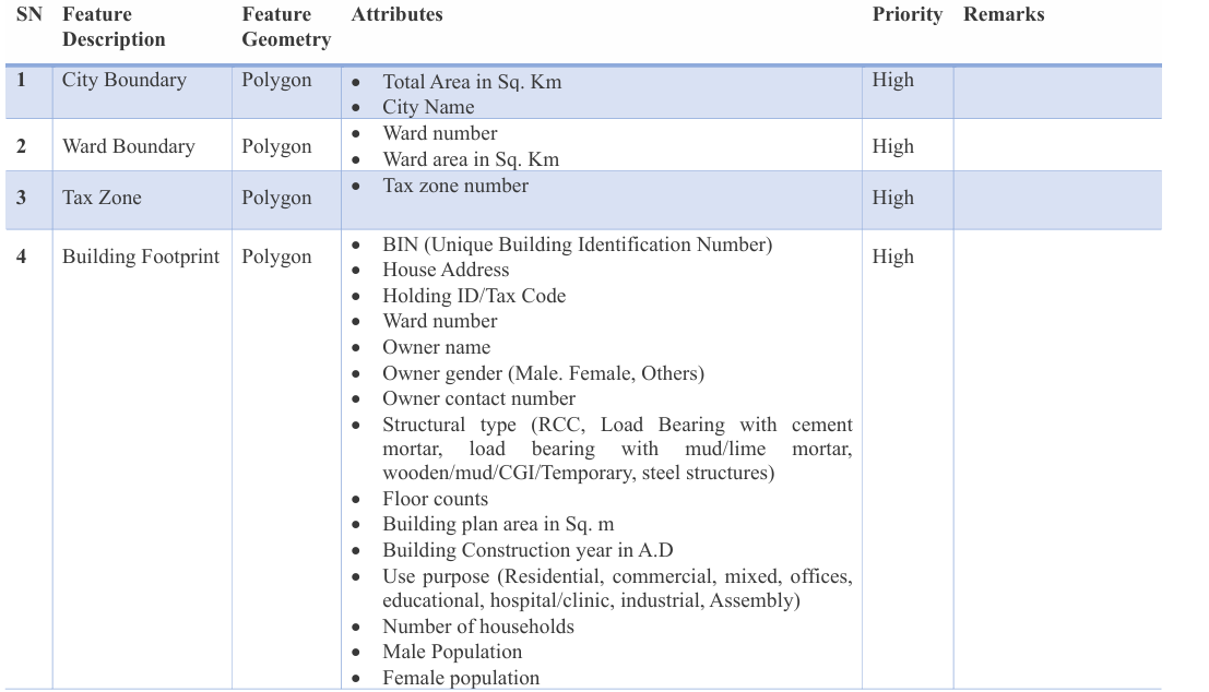
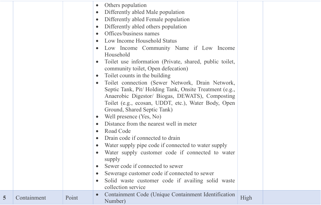
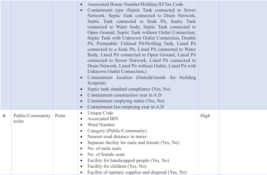
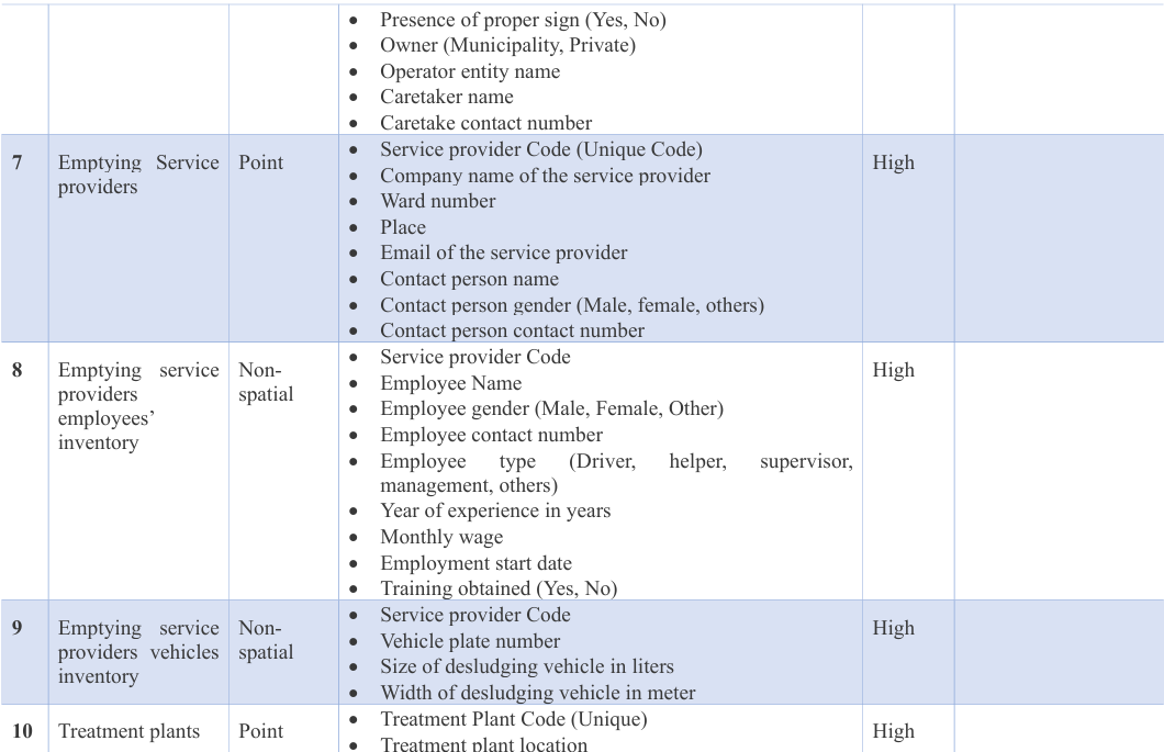
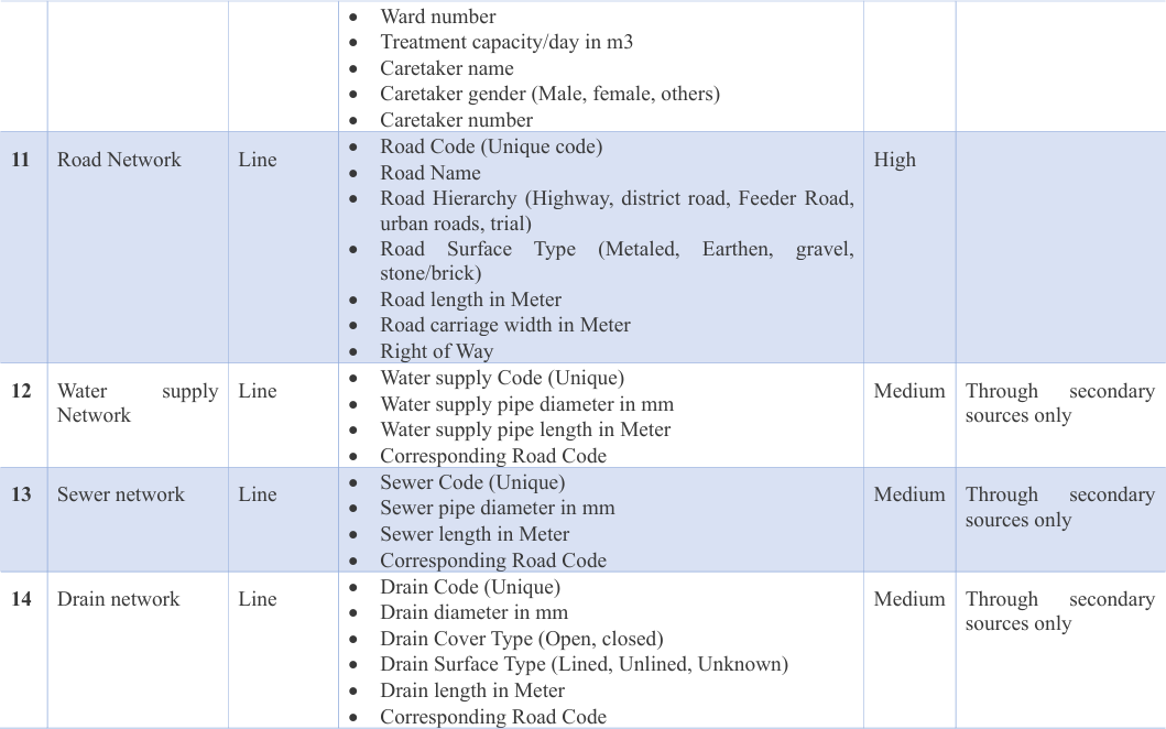
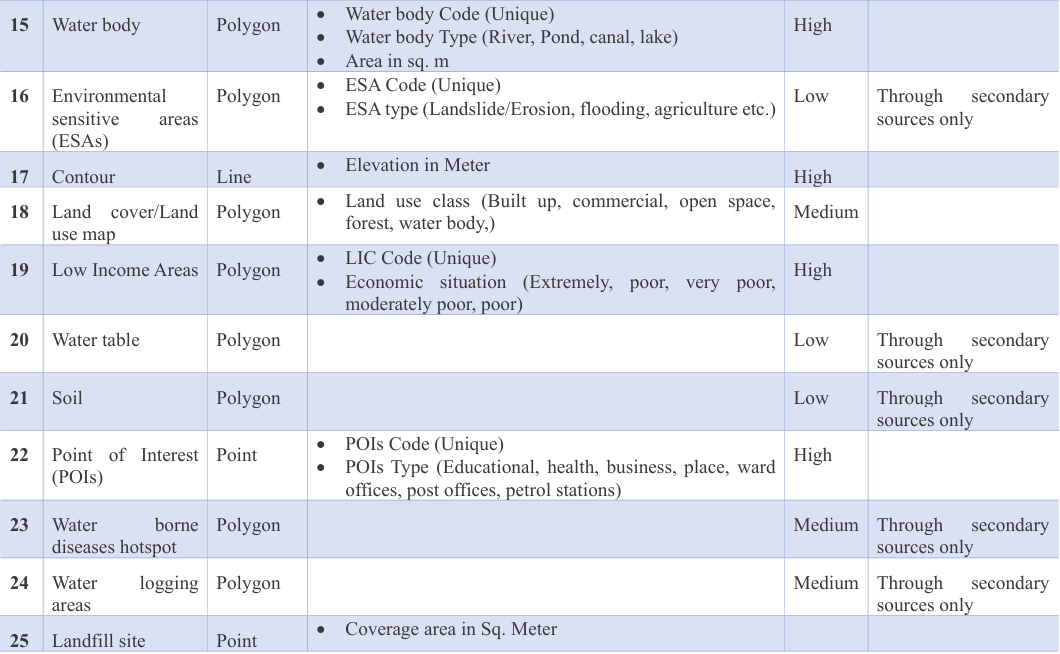
IMIS promotes sanitation as a public service and integrates sanitation data with inter related urban sub-sectors domain (e.g., water supply, solid waste management and transportation networks, sewer networks). Multiple types of spatial and non-spatial data sources have been carefully identified by the IMIS development team comprises of System Analyst, Data Analyst, GIS expert and sanitation domain experts with focusing on CWIS core outcomes and functions. IMIS data requirement checklist is presented in Appendix A which describes necessary data layers and its necessary attributes for efficient planning, management and M&E of sanitation system and service delivery as well as for overall urban management of the Local Governments.
Establishing a geo-database for IMIS involves creating a structured and organized repository for storing spatial data and non-spatial data. All these data layers are seldomly readily available in LGs. In addition, even available data is often outdated or missing key attribute information. Therefore, a series of steps need to be followed to establish required database of IMIS that may include data acquisition through field survey and conversion of relevant spatial data from various sources, such as satellite imagery, master plan data and existing paper maps as well.
Establishment of GIS database for IMIS shall be led by a competent, qualified, and experienced consultant who has a demonstrated track record in working in the geospatial domain with previous experience in conducting city wide geospatial survey for establishing the GIS database. The consultant must have a full time GIS Expert with at-least Bachelor’s degree in GIS with 5 years of working experience in their team.
WorkFlow
The general workflow for establishment of GIS database for IMIS is outlined as follows:
Exploration data available with local government & other stakeholders
A key informant interview (KIIs) with local government officials and other stakeholders (e.g. Central Bureau of Statistics, Ministry of Local Government, etc.) is a first step in for ascertaining availability of various spatial and non-spatial data needed for IMIS. During
the KIIs, availability/unavailability, creation year and form of data(digital/paper) must be ascertained for each data. In case of unavailability of data, it must be inquired if the data can be generated with the help of KIIs with any officials of LGs or other stakeholders. In that case, the person who can provide information must be identified as well.
Acquisition of available data and standardization
Acquisition of high-resolution satellite imagery
Digitization of data-layers using high-resolution satellite imagery
Field verification of buildings, roads, sewerage, drainage and water supply
Field survey for collection of attribute data
Composition of survey team
In addition to enumerators, field supervisors are needed to manage field work implementation and monitoring of enumerators to ensure that field survey get completed within the intended allocated time as well as to provide any assistance required by enumerators related to the filed mobile application or the questionnaire. Enumerators must maintain regular communication with the enumerators on the daily basis. The recommended ratio of supervisor and enumerator is 1:20.
Conducting field survey using MerginMaps
A field survey using MerginMaps requires extensive training to enumerators on how to use MerginMaps and conduct data collection accurately and efficiently. Besides training to enumerators, a curtailed training to a person with GIS knowledge to act as a survey coordinator who will setup/modify forms in MerginMaps and performs/monitors the synchronization of collected data with the use of QGIS software is required. The IMIS Field Data Collection User Manual for Coordinator and IMIS Field Data Collection User Manual for Enumerators are attached with this report. An elaborate training shall be provided for both Coordinator and Enumerators before the commencement of survey. A general workflow for conducting a field survey using MerginMaps is as follows:
- Designing the Survey Form in QGIS that includes the required data fields to capture information during the field survey. The form needs to be tailored to specific data collection needs.
- Configuring the GIS data and survey form in QGIS before conducting the survey in the field such that there is direct linkage between survey form with the relevant data layers with needed styling, field validation rules and skip logics. It is essential to incorporate data validation rules with the survey form to minimize errors during the field data collection.
- Acquiring necessary space privilege on MerginMaps for data storage by purchasing a suitable plan that is most appropriate as the requirement of the project and transferring the QGIS project in MerginMaps.
- Providing elaborate training to both coordinator and enumerators about the use of MerginMaps applications (web and mobile apps). Enumerators are given training related to mobile application only whereas coordinators are given training related to both mobile and web applications. Mobile application is primarily used during the field survey whereas web application is meant both for configurating the survey as well as monitoring and synchronization of collected field data.
- Collection of data in the field by enumerators with a mobile device loaded with MerginMaps application. Enumerators can collect data and input the information directly into the digital form.
- Synchronizing data collected in the field with the central database using MerginMaps cloud. The step ensure that all data is consolidated and updated in the main GIS database of the project. Enumerator performs the synchronization of data once the surveyors have a strong internet connection. Synchronizing data using mobile data connection is not recommended.
- Regular monitoring of collected data by coordinators to ensure that any inconsistencies or inaccuracies are identified and addressed properly by conveying the information to field enumerators through supervisors.
Appendix A. DATA DICTIONARY FOR GIS-DATABASE
Appendix B. CHECKLIST FOR CENSUS SURVEY OF BUILDING & CONTAINMENT ASSESSMENT FOR IMIS
Date: _ _/_ _/ _ _ _ _
Name of Surveyor:
Name of Respondent:
Gender (Male/Female/Others):
Contact number of Respondent:
Owner Information
- Name of Owner:
- Gender (Male/Female/Others):
- Contact number of Owner:
- Ward:
- House Address:
- Road Code (XXX):
- Road Name:
- Tax Code/ Holding ID:
Building Information
1.What is the construction type of the building?
-
- RCC
- Load bearing with cement mortar
- Load bearing with mud/lime mortar
- Wooden/Mud/CGI /Temporary
- teel structure
- Other (Specify):
- What is construction year of the building (YYYY AD)?
- Number of floor (including ground floor):
- Is the Building Low Income Household?
- Yes
- No
- If Q.12 is Yes, Low Income Community Name, if applicable?
- What is the use purpose of the building?
- Residential
- Commercial
- Mixed (Residential and Commercial)
- Offices
- Educational
- Hospital/clinic
- Industrial
- Assembly
- Other (Specify):
- What business /governmental institutions/offices/educational entities are present in the building? List out names.
- How many households (HHs) are living in the building?
- How many people are living in the building including all households?
- Male:
- Female:
- Others:
If differently abled:
- Male:
- Female:
- Others:
Toilet & Containment Information
-
Do you have a toilet on your premises?
- Yes
- No
-
If Q18 “No”, where do your family go for defecation?
- Use Community Toilet
- Open defecation at water bodies/ open ground
- Others (Specify):
-
If Q18 “Yes”, how many toilets do you have?
-
If Q18 “Yes”, how many households have shared toilets?
-
If Q18 “Yes”, Where does your toilet connection go?
- Sewer Network
- Drain Network
- Septic Tank
- Pit/ Holding Tank
- Onsite Treatment (e.g., Anaerobic Digestor/ Biogas, DEWATS)
- Composting Toilet (e.g., ecosan, UDDT, etc.)
- Water Body
- Open Ground ix. Shared Septic Tank
-
If Q22 “Septic tank”, where does your outlet connection go?
- Septic Tank connected to Sewer Network
- Septic Tank connected to Drain Network
- Septic Tank connected to Soak Pit
- Septic Tank connected to Water body
- Septic Tank connected to Open Ground
- Septic Tank without Outlet Connection
- Septic Tank with Unknown Outlet Connection
-
If Q22 “Holding Tank/ Pit”, what type of Pit is it?
- Double Pit
- Permeable/ Unlined Pit/Holding Tank
- Lined Pit
-
If Q24 “Lined Pit”, where does your outlet connection go?
-
Lined Pit connected to a Soak Pit
-
Lined Pit connected to Water Body
-
Lined Pit connected to Open Ground iv. Lined Pit connected to Sewer Network
-
Lined Pit connected to Drain Network
-
Lined Pit without Outlet
-
Lined Pit with Unknown Outlet Connection
-
If Q 22 “Sewer Network” or Q 23 ”Septic Tank connected to Sewer Network” or Q 25” Lined Pit connected to Sewer Network” then Sewer Code?
-
If Q 22 “Drain Network” or Q 23 ”Septic Tank connected to Drain Network” or Q 25” Lined Pit connected to Drain Network” then Drain Code?
-
-
If Q22 “Septic Tank”, does septic tank have at least 2 chambers, outlet at top, sealed/lined base, and walls?
- Yes
- No
- Don’t know
-
If Q22 “Septic Tank/ Pit/Holding Tank”, When was the containment constructed (YYYY AD)?
-
If Q22 “Septic Tank/ Pit/Holding Tank”, Where it is located?
- Inside the building footprint
- Outside the building footprint
- Don’t know
-
If Q22 “Septic Tank/ Pit/Holding Tank”, have you ever emptied your septic tank/holding tank/pit?
- Yes
- No
-
If Q29 “Yes”, when was it last emptied (year)?
-
If Q22 “Septic Tank/ Pit/Holding Tank”, what is the estimated size of your Septic Tank/ Pit/Holding Tank”?
-
If Q19 “Use Community Toilet”, then name of Community Toilet?
-
If Q22 “Shared Septic Tank”, BIN of building that has septic tank pre-connected?
Water Use Information
- What is the main source of water for drinking?
-
Municipal/Public Water Supply
-
Dug Well
-
Tube Well
-
Spring/River/Canal/Stone Spout
-
Rainwater
-
Private Tanker Water
-
Jar Water
-
Others
-
- If Q24, “Municipal/Public water supply”, what is your water supply customer ID?
- If Q24, “Municipal/Public water supply”, what is your water supply Pipe ID?
- Do you have well on your premises?
- Yes
- No
- If Q27, “Yes”, what is distance of well from the nearest septic tank/holding tank/pit?
Solid waste Information
- Do you have a solid waste collection service?
- If Q29 “Yes”, what is name of the solid waste service provider?
- If Q29 “Yes”, what is your solid waste customer ID