OPEN GIS DATA EXTRACTIONS PROCESS FRAMEWORK
- Building Footprints using Google Open Buildings
- Output Illustrations
- Road Network using Open Street Maps (OSM) Database
- Output Illustrations
- Extraction of Waterbodies and Rivers using Open Street Map (OSM) Database
- Output Illustrations
- Extraction of Elevation Profile using SRTM or ASTER DEM
- Output Illustrations
Building Footprints using Google Open Buildings
Stepwise Process Flow Details
-
Step 1: Access the Data Source o Start by visiting the Google Open Buildings website at https://sites.research.google/open-buildings/ https://sites.research.google/open-buildings/
o Here you'll find all necessary resources, tools, and information about the building database you'll be working with.
-
Step 2: Define your Study Area o Next, define the region of interest for which you want to extract building data. To do this, visit the polygon selection website at https://arthurhttps://arthur-e.github.io/Wicket/sandbox-gmaps3.htmle.github.io/Wicket/sandbox-gmaps3.html https://arthur-e.github.io/Wicket/sandbox-gmaps3.html
o Use the “Draw a shape tool” to draw your study area, and then copy the resulting code that defines this polygon.
-
Step 3: Use the Colab Python Notebook Script o Now, open the Colab Python Notebook script at open_buildings_spatial_analysis_examples.ipynb - Colaboratory https://colab.research.google.com/github/google-research/google-research/blob/master/building_detection/open_buildings_spatial_analysis_examples.ipynb
(google.com) https://colab.research.google.com/github/google-research/google-research/blob/master/building_detection/open_buildings_spatial_analysis_examples.ipynbo Paste the code of your study area (from Step 2) into the designated area in the Colab notebook. After that, run the script. This will initiate the process of extracting data for buildings located within your selected area.
-
Step 4: Authenticate your Google Drive o The script requires access to your Google Drive to store the resulting data. Follow the prompts of the script to authenticate your Google Drive. This will typically involve clicking on a link, signing into your Google account, and then copying and pasting an authentication code back into the script.
-
Step 5: Extract and Save the Building Data o Upon successful authentication, the script will then proceed to extract the building data and save it into your Google Drive in a CSV (commaseparated values) format.
-
Step 6: Download and Load the Data into QGIS
o Next, go to your Google Drive, find the saved CSV file, and download it onto your computer. Then, open your QGIS software, and load the CSV file into it.
-
Step 7: Validate the Data o To ensure the data is accurate and up to date, overlay the building boundaries onto the latest Google imagery available in QGIS. Check each building and make sure they are correctly represented. If there are any missing buildings, you can add them manually.
-
Step 8: Export the Data o After validation, you can now prepare your data for further use. Export the building data as a shapefile, which is a common format used for geospatial vector data.
-
Step 9: Clip the Data to your Study Area o The last step is to clip the data to your defined study area. Select "Vector" > "Geoprocessing Tools" > "Clip" from the top menu. Select the Input layer as the building data shapefile and the Overlay layer as your study area boundary. This will remove any buildings that fall outside of your region of interest, resulting in a clean and concise dataset that only includes the buildings you are interested in.
Output Illustrations
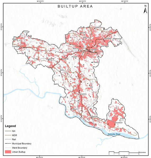
Figure 3 Illustrations of built-up extractions, Dhanbad (India).
Source – Dhanbad spatial analysis, Innpact Solutions and GWSC
Road Network using Open Street Maps (OSM) Database
Stepwise Process Flow Details
-
Step 1: Load the Study Area Boundary in QGIS o Start your QGIS software and load the boundary file of your study area.
You can do this by clicking on "Layer" in the top menu, then selecting "Add Layer" > "Add Vector Layer" and navigating to the file on your computer.
-
Step 2: Install the OSM Downloader Plugin in QGIS o To download the data from OpenStreetMap, you will need a specific plugin. From the top menu, select "Plugins" > "Manage and Install Plugins". Search for "OSM Downloader" and install it.
-
Step 3: Select the Area of Interest Using the OSM Downloader Plugin o Use the OSM Downloader plugin to select your area of interest. You can do this by selecting "Plugins" from the top menu, then "OSM
Downloader" > "Download Data". A map will appear where you can draw a rectangle around your area of interest.
-
Step 4: Download and Save the OSM Data o Once you've selected the area, click "OK" to start the download. The data will be saved as a .osm file on your computer.
-
Step 5: Select Only Road-Type Polyline Features from the Downloaded OSM
Data o Now, load the downloaded the .osm data into QGIS by clicking on "Layer" in the top menu, then "Add Layer" > "Add Vector Layer". In the layer list, find and select the "lines" layer, which contains the road data. Right-click on the "lines" layer and select "Open Attribute Table". Here, you can select and isolate only the road-type polyline features.
-
Step 6: Export the Selected Road Data as a Shapefile o Once you've selected the road data, right-click on the "lines" layer in the layer list and select "Export" > "Save Features As". Choose the format as "ESRI Shapefile" and choose the location on your computer where you want to save it.
-
Step 7: Clip the Shapefile to your Study Area o You will now clip the road data shapefile to your study area. Select
"Vector" > "Geoprocessing Tools" > "Clip" from the top menu. In the Clip
tool, set the Input layer as the road data shapefile and the Overlay layer as your study area boundary. Run the tool to clip the road data to your study area.
-
Step 8: Recategorize the Road Types o Finally, you may want to recategorize the road types to match the government categories such as National Highway, State Highway, etc. Open the attribute table of the clipped road data shapefile and manually edit the road type categories to align them with the government standards.
Output Illustrations
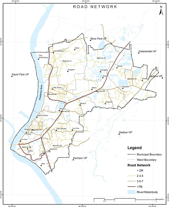
Figure 4 Illustrations of road network extracted from open source, Tarabo (Bangladesh):
Source – CWIS spatial analysis, Innpact Solutions and GWSC
Extraction of Waterbodies and Rivers using Open Street Map (OSM) Database
Stepwise Process Flow Details
- Step 1: Download OpenStreetMap (OSM) Data for Your Study Area o Start by loading your study area in QGIS and using the OSM Downloader plugin to download the OSM data for your area of interest, as explained in the previous steps. This data will be saved as an .osm file on your computer.
-
Step 2: Load OSM Data into QGIS o Next, load the downloaded .osm data into QGIS by navigating to "Layer" in the top menu, then selecting "Add Layer" > "Add Vector Layer". Browse to the location of your .osm file and load it into QGIS.
-
Step 3: Select Waterbody and River Features o In the OSM data, the water bodies and rivers are generally contained in the 'multipolygons' layer. In the layer list, select the 'multipolygons' layer and then right-click to select "Open Attribute Table". This will bring up a list of all features in this layer. o From here, filter and select the features that represent water bodies or rivers. This can be done by setting up a query in the attribute table where the 'type' or 'name' of the feature represents water bodies or rivers.
-
Step 4: Export Selected Features as a Shapefile o Once you've selected the relevant waterbody and river features, you can export them as a shapefile for further analysis. To do this, right-click on the 'multipolygons' layer in the layer list and select "Export" > "Save Features As". Choose "ESRI Shapefile" as the format and select a location on your computer to save the file.
-
Step 5: Clip the Shapefile to Your Study Area o Finally, use the clip tool to trim your shapefile to match the boundaries of your study area. Navigate to "Vector" > "Geoprocessing Tools" > "Clip" in the top menu. Set the input layer as the waterbody and river shapefile and the overlay layer as your study area boundary. Run the tool to perform the clipping operation. The result is a shapefile that contains only the water bodies and rivers within your study area.
Output Illustrations
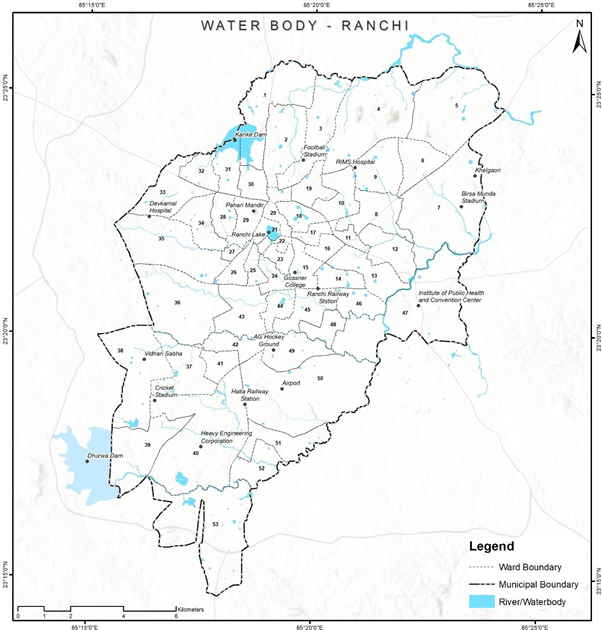
Figure 5 Illustrations of extracted water bodies map, Ranchi (India)
Source – CWIS spatial analysis, Innpact Solutions and GWSC
Extraction of Elevation Profile using SRTM or ASTER DEM
Stepwise Process Flow Details
- Step 1: Install the SRTM Downloader Plugin o Open QGIS. o Go to the Plugins menu. o Select "Manage and Install Plugins." o In the Plugins dialog, search for "SRTM Downloader." o Click on the plugin and then click the "Install Plugin" button to install.
- Step 2: Access the SRTM Downloader Plugin o Once the plugin is installed, you should see a new menu item called "SRTM Downloader" in the QGIS toolbar.
- Step 3: Define Study Area o Zoom in to your study area in QGIS using the zoom and pan tools.
- Use the rectangle or polygon selection tool to define the area you want to download the SRTM data for. You can find these selection tools in the QGIS toolbar.
- Step 4: Run the SRTM Downloader Plugin o Click on the "SRTM Downloader" menu in the QGIS toolbar. o Login using the Earthdata user account.
- In the SRTM Downloader dialog, choose the output folder where you want to save the downloaded data.
- Step 5: Start the Download o Click the "OK" button to start the download process. The plugin will automatically download the SRTM data for the defined study area.
- Step 6: Process the Downloaded Data o Once the download is complete, the SRTM data will be available in the output folder you specified. o You can now use the downloaded SRTM data for your analysis in QGIS.
Output Illustrations
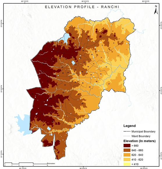
Figure 6 Illustrations of extracted elevation profile, Ranchi (India)
Source – CWIS spatial analysis, Innpact Solutions and GWSC